
East Lothian has some of the best agricultural land in the British Isles.
It lies to the east of Edinburgh, Scotland's capital city.
Bounded by the Firth of Forth, the North Sea and the Lammermuir
hills, it's a photographer's paradise: - a mosaic of fields
("look at your landscape and lick your lips" - Hilary Cochran, Knowes Farm Shop) and plenty of trees for
autumn colour, open hillsides riven by 'cleuchs' where ages ago melting ice trickled out from the glaciers, wild rocky shores, unspoilt
beaches (for the most part), and fascinating stone-built villages, castles, harbours, mansions and churches. And superb golf courses.
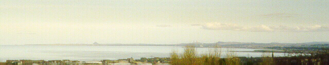
Click on this picture to open a new window with an aerial overview where East Lothian meets the North Sea
Coalmining, salt panning, pottery, were once important industries in the western part of the county. They're vividly commemorated at Prestongrange on the coast road from Musselburgh to North Berwick. Here a great old beam engine, which pumped water out of the under-sea mines, is now a showpiece for visitors - for tourism is one of our most important industries nowdays.
East Lothian Council, the local government authority, provides support for a number of small museums in the county; its latest enthusiasm is for Nortrail, the walk or cycle route along the coast of all the countries bordering the North Sea. East Lothian has already almost completed the John Muir Coastal Path from Musselburgh, the town close to Edinburgh, to Dunglass on the border with Berwickshire.
Quite the most interesting and comprehensive description of the area must be the late Frank Tindall's The Memoirs and Confessions of a County Planning Officer written shortly before his death in 1998. It's published by The Pantile Press (ISBN 0 953401308), and is available from The John Muir Trust, price £25.To quote from the dust cover:
Frank Tindall did more than virtually anyone else to preserve the best of our county towns. He did it at a time when the town-planning establishment ridiculed his ideas. While other planners awarded each other honours for ugly redevelopments that were seen by the fashionable as exciting and innovative, Frank Tindall's approach to planning was to see beauty in what was already there, to find new uses for, and ways to work on, restoring old buildings and to keep the ancient street plans of the towns for which he was responsible.
This book is not a dusty record taken from Council Minutes but a lively memory of how things were and how they were changed. It is an entertaining and illuminating account of what the author described as "the halcyon days of Town and Country planning".